Case study · Logistics & innovation
Drone inventory: from flight to useful data.
A publishing-logistics pilot exploring pallet identification and rack inspection. Capturing images is only the starting point: the challenge is turning them into reliable information while it is still relevant.
Operational figures reported by the author: one person, 15 eight-hour working days. These are neither a manufacturer benchmark nor measurements independently verified against mission logs.
01 / The initial question
In a high-density warehouse, checking physical locations against system records takes time and requires visibility of levels that are difficult to inspect from the floor. The project explored a drone as a tool for inventory verification and visual evidence collection.
The project presentation identifies a DJI Mavic 3 Enterprise platform. The initial ambition was to automate part of the checks and make acquisition repeatable. This describes the objective, not proof of a fully autonomous or real-time inventory solution.
02 / The work before take-off
My contribution focuses on connecting operational processes, information requirements and stakeholder coordination. The start-up materials document the pilot scope, preparation of rack mappings and comparison of captured data with the warehouse-system reference.
The geometric model needs columns, levels, clear heights and beam dimensions. The sources use millimetres, centimetres and metres, making unit normalisation essential. Missing identifiers, duplicates and inconsistent sequences can undermine the association between an image and its location.
Real racks are not uniformly regular. The documentation covers fire-service access gaps, different level heights and first bays that differ from the rest of the row. These exceptions belong in the configuration: copying a standard geometry without checking the physical layout is insufficient.
03 / From capture to reconciliation
The designed workflow includes area mapping, an inventory reference extract, image and barcode capture, result transfer and reconciliation with the warehouse system. The specifications also include operator selections and commands. Automation must therefore be assessed across the entire process, not flight alone.
Reading a barcode does not establish the quantity or contents of a pallet. Pallet identification, location association and content checking are separate questions. A missing read must remain an exception to investigate, not automatically become an empty location.
A reliable comparison should retain acquisition timestamps and use a consistent warehouse-system snapshot. Movements between extraction, flight and analysis need reconciliation; otherwise timing differences can appear to be inventory errors. These are control requirements, not capabilities claimed here as delivered.
04 / What the images show
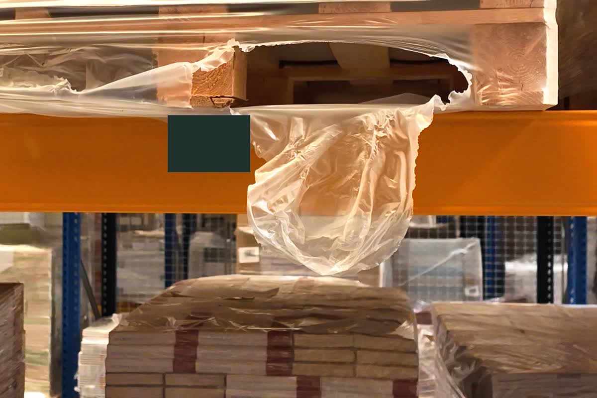
The photographs show hanging stretch film, irregular wrapping and uneven visibility. They help direct targeted checks, but do not by themselves demonstrate structural rack damage or stock discrepancies.
Visual inspection has value separate from inventory counting. It documents exceptions for discussion with operations; classification and any intervention remain subject to on-site checks and company procedures.
Evidence from the field

The project in motion
Excerpts from the original materials. Selected framing and identifying details redacted; audio and metadata removed. Photographs document visual observations, not acceptance-test results.
05 / The numbers and what they mean
| Metric | Value | Calculation / limitation |
|---|---|---|
| Scope | ≈13,000 pallet locations | Approximate scope reported by the author; not a count of successfully identified pallets. |
| Duration | 15 days × 8 hours | Reported commitment for one dedicated person. |
| Person-hours | 120 | 15 × 8 × 1. Reported overall effort, not net flight time. |
| Derived average pace | ≈108 locations/hour | 13,000 ÷ 120; about 867 locations/day. Indicative average, not a constant rate. |
| Battery | 20–30 minutes | Reported operating range, dependent on pilot handling; not DJI’s nominal endurance. |
06 / The limitations
Endurance and interruptions
Replacing a battery every 20–30 minutes requires changeovers, charging management and session restarts. The range also depends on pilot handling and cannot alone establish the total number of batteries used during the campaign.
A continuously committed resource
The reported process occupies one person throughout. The drone does not eliminate labour: it shifts work to piloting, supervision and acquisition management. The 120 hours exclude any additional support personnel, whose effort has not been quantified.
Coverage lags behind change
Fifteen working days for the stated scope means that early observations may already be outdated when acquisition ends. Subsequent analysis risks describing a warehouse situation that has already changed.
Data quality and downstream work
Reflections, obscured labels, wrapping and non-uniform geometry call for verification. Without complete logs, read rates, rework, time distributions and final accuracy cannot be quantified. Accuracy targets in planning documents are not measured outcomes.
The lesson: shorten the time to a decision.
In this context, the drone provides a useful observation and evidence-collection channel, but labour requirements and the delay between capture and analysis limit the effectiveness of wide-scale inventory checking. My assessment is to prioritise targeted checks and shorter cycles, judging automation by the availability of reconciled data. Scaling requires valid-coverage, exception and decision-latency measurements, plus comparison with an equivalent manual baseline. The available materials do not establish ROI, realised savings or improvements in OTIF and throughput.
Sources and scope
Summary of start-up documentation, specifications and mappings, the project presentation, and photographs/videos supplied by the author. Operational figures come from his account; averages are explicit calculations using those approximate values. Exact campaign dates and final mission logs are unavailable for independent verification. Full documents, detailed inventory data, prices, third-party names and infrastructure information are not published. This is a personal project assessment, not an official statement by the companies involved.